Firefox OS and Nokia Offline Maps

Firefox OS and Nokia Offline Maps
 
A nice discovery when using the the pre-release of Firefox OS.
NOKIA OFFLINE MAPS


Users can download Maps from Nokia using FireFox OS.

Installing FireFox simulator 0.7 (http://onsoftware.en.softonic.com/hands-on-withmozillas-firefox-os)

Then using Firefox install from local file.


Go the Simulator of FireFOX OS.
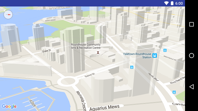
GO TO MAPS

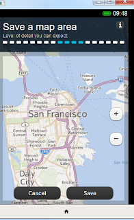
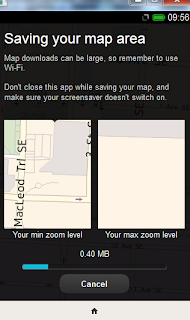
Nokia Powered Maps then give you the option to download areas.
Save the Maps (between 4 & 18mb in testing)

Disconnect - Firefox  'work offline'


View the maps in Offline Mode

Note: This is still alpha - there will be bugs...

Please Report Bugs. https://github.com/mozilla/r2d2b2g/issues

Readmore..

Avoid traffic jams with Bing Maps Traffic in Windows 8

The Jakarta Traffic congestion is a way of life. It said most of the residents of Jakarta, is often stuck congestion. There are several ways to avoid bottlenecks, through the use of real-time traffic monitoring technology is one of them.
Real-time traffic monitoring requirements for road infrastructure. Unfortunately, it is not yet installed the infrastructure in Indonesia. Windows 8 Bing Maps can display conditions and Lithuania established Teya Garda pretty good, through the use of a wide range of information available. Of course, there are all kinds of restrictions, only monitor certain streets in Jakarta alone Bing Maps (can not be monitored the Street / small alleys.
Tablet PC with touch screen, we can go to Bing Maps, then brush from the bottom to the top, or if you use a mouse, right-click, see the following menu:


Where we can click "show traffic" to look at the road congestion. Seems that Jakarta traffic is less dense from Bing Maps map to see:


Road congestion is shown by the color code: black, red, yellow and green. Black is trapped down, while the green is the most smoothly.
Bing Maps provide services from Nokia Navteq map location and real-time traffic information service. A country has a good infrastructure, we can even get to the main road or path information on the speed of the vehicle, such as in a road accident.
Navteq technology is highly advanced because it can analyze the traffic from a variety of sources, such as sensor devices from a variety of business and consumer information from government sources or from sources other traffic recording.
Unfortunately,
Indonesia in as much detail as possible the information, if any, has no information ... However, if you already have a Windows 8 tablet, and then you can try the expected road congestion in Jakarta with Bing Maps navigation.

Readmore..

NAVTEQ Network For Developers

Hello World

Readmore..

Mining Atlas

Mining Atlas - Explore over 10'000 Mines and Projects

A nice integration of using Google Earth that allows users to explore mining activities across the planet, either use the search bar or zoom into areas using the map to find mines.

The tour feature is a good addition that zoom,pans and tilts the Google earth camera around the selected mines - tour is automatically on as default.

There are also printing and distance measurement tools (in KM) that can be used.


To experience this altas go to:

http://www.mining-atlas.com/featureSection/The_Biggest_Mines_in_the_World_Introduction.php

Source and thanks to Dominique Pitot

Readmore..

Google Maps Android API v2


Google Maps Android API v2

New Features

With the new version of the Google Maps Android API, developers can utilize Google Maps to its fullest. We’ve incorporated many of the highly-requested features developers want, such as:

  • More dynamic and flexible UI designs for large screen Android devices, such as tablets, using Android Fragments

  • Adding more Google Maps layers in their apps including satellite, hybrid, terrain, traffic and now indoor maps for many major airports and shopping centers

  • The ability to create markers and info windows with less code
  • The maps in the Google Maps Android API v2 can be tilted and rotated with easy gestures, giving users the ability to adjust the map with an orientation that makes sense for them. At any zoom level, you can pan the map, or change its perspective with very little latency thanks to the smaller footprint of the vector-based map tiles. Many cities, when viewed close up, will have 3D buildings visible, as viewable in the below picture of Vancouver, Canada.


26 minute youtube video of the Google Maps v2 update:
 

source:
http://googlegeodevelopers.blogspot.com/2012/12/better-maps-in-your-android-apps.html


Readmore..
 
© Copyright 2010. yourblogname.com . All rights reserved | yourblogname.com is proudly powered by Blogger.com | Template by o-om.com - zoomtemplate.com